


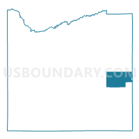
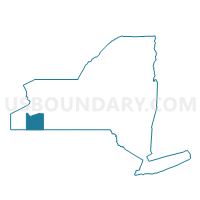
Voting District 150001, Cattaraugus County, New York
About
Outline

Summary
| Unique Area Identifier | 625705 |
| Name | Voting District 150001 |
| County | Cattaraugus County |
| State | New York |
| Area (square miles) | 32.40 |
| Land Area (square miles) | 32.38 |
| Water Area (square miles) | 0.02 |
| % of Land Area | 99.94 |
| % of Water Area | 0.06 |
| Latitude of the Internal Point | 42.23787260 |
| Longtitude of the Internal Point | -78.38453310 |
Maps

Graphs
Select a template below for downloading or customizing gragh for Voting District 150001, Cattaraugus County, New York


Neighbors
Neighoring Voting District (by Name) Neighboring Voting District on the Map
- Voting District 100003, Cattaraugus County, NY
- Voting District 130001, Cattaraugus County, NY
- Voting District 130002, Cattaraugus County, NY
- Voting District 140001, Cattaraugus County, NY
- Voting District 150002, Allegany County, NY
- Voting District 180001, Cattaraugus County, NY
- Voting District 220001, Allegany County, NY
- Voting District 300000, Allegany County, NY
- Voting District 370000, Cattaraugus County, NY
Top 10 Neighboring County Subdivision (by Population) Neighboring County Subdivision on the Map
- Cuba town, Allegany County, NY (3,243)
- Franklinville town, Cattaraugus County, NY (2,990)
- Hinsdale town, Cattaraugus County, NY (2,168)
- Ischua town, Cattaraugus County, NY (859)
- New Hudson town, Allegany County, NY (781)
- Lyndon town, Cattaraugus County, NY (707)
- Humphrey town, Cattaraugus County, NY (687)
- Oil Springs Reservation, Allegany County, NY (1)
- Oil Springs Reservation, Cattaraugus County, NY (0)
Top 10 Neighboring Unified School District (by Population) Neighboring Unified School District on the Map
- Cuba-Rushford Central School District, NY (6,402)
- Franklinville Central School District, NY (4,675)
- Hinsdale Central School District, NY (2,979)
Top 10 Neighboring State Legislative District Lower Chamber (by Population) Neighboring State Legislative District Lower Chamber on the Map
Top 10 Neighboring State Legislative District Upper Chamber (by Population) Neighboring State Legislative District Upper Chamber on the Map
Top 10 Neighboring 111th Congressional District (by Population) Neighboring 111th Congressional District on the Map
Top 10 Neighboring Census Tract (by Population) Neighboring Census Tract on the Map
- Census Tract 9610, Cattaraugus County, NY (4,558)
- Census Tract 9505, Allegany County, NY (3,799)
- Census Tract 9504, Allegany County, NY (3,649)
- Census Tract 9622, Cattaraugus County, NY (2,984)
- Census Tract 9402, Allegany County, NY (1)
- Census Tract 9402, Cattaraugus County, NY (0)